Durham State Forest: ATNO Research and Activation POTA K-4772 (Plus K-2396)
One of my objectives for the good weather in Maine during my holiday travel was to get out to the convenient and interesting parks in the area. As highlighted by W1DED's map documenting POTA MAINE, there are a couple of Midcoast Maine parks that had no activations ever by 2022: both the Durham State Forest and Ducktrap River Wildlife Management Area. The reason? They're poorly documented locations with no convenient drive-up-and-know-you're-there place. The WMA even overlaps the local Ducktrap Preserve, but you'd have to figure out what that meant and where to hike. And the forest, well, the forest barely even seems to exist on the internet by that name! No official state information and just lots of OpenStreetMap references. I looked to take on the forest to understand where it was, what the access looked like, and then get out there and put the park on the air.
So, the adventure for Durham State Forest (K-4772, wiki).
Since it's not notable enough to be listed by anything zoom to the area on Google Maps, I used SOTl.as for ease of access to OpenStreetMap's view. The latter confirms the name and presumed location, but doesn't really confirm state ownership boundaries or access. Google Street View also didn't provide much information looking for obvious (hint hint) signage or access points. A roundabout with Maine.gov search didn't show any fruitful results for it. However, I did find two useful references for this adventure:
- Maine Forest Service: Boundary Paint Marking Standards (almost at the bottom of the page)
- Maine Inland Fisheries & Wildlife: Exploring the Outdoors on Private Land
From these, I concluded that so long as the state land wasn't posted or marked with boundary paint, my low-impact radio operation should be straightforward and not require specific permission from a state forest service representative on a holiday weekend. So, what about those land boundaries?
 |
| sotl.as OSM image of the Durham State Forest boundary |
The Maine Geolibrary Parcel Viewer Application eventually also came up in my searching the State of Maine for land resources. The forest I was after is located at "Bog Rd and Rocky Rd, Northport, ME" and shows three lots that line up with the expected state land: R1-30, R1-31, R1-46.
 |
| Parcel Viewer Application at the expected park location |
Location, shapes, now who owns this? Well, the Parcel Viewer Application splash screen says that all the details are supposed to be the concern of the local municipality. Here, Northport, ME. Over to the municipal web site for their latest Map and Lot Book. And where are our entries for these lots?
- 00824 001 STATE OF MAINE FORESTRY 92 ROCKY ROAD R01-30
- 00825 001 STATE OF MAINE FORESTRY 91 ROCKY ROAD R01-31
- 00874 001 THE BUREAU OF PARKS AND 135 ROCKY ROAD R01-46
Perfect! The municipality thinks the state owns these, so location and access are mostly ready. At this point, it was getting late on New Year's Eve and getting in bed before the local year rolled over was a higher priority. Why not just get out there and see how it goes?
My dad and I hit the road in his van with my KX3 kit-in-a-camera bag on my shoulder and a camp chair with my mother's old car-helper wool blanket in the back. After the first curve on Rocky Rd coming from Rt 1, what do we find but the perfect opportunity:
 |
| A marked trail on state-owned lot R1-30 with plenty of trees; it's a forest, of course. |
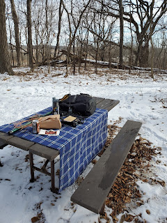
There's no decent option for parking. Fortunately, I'm the passenger on this adventure and, with an activation location located, I had my dad drop me off and head off to run errands in Belfast while I operated. Setup with a throw line and 29' speaker wire antenna on the edge of the marked trail was easy. Heck, putting up a longer wire in the trees would have been easier! The camp chair with wool blanket is really nice and the camera bag works great for an operating position.
 |
| View of my selected operating location just inside the forest on the edge of the trail |
The trail also crosses over Rocky Rd to lot R1-31 to places unknown. I'm here to play radio, not hike through the Maine woods! If you really wanted to park, you could probably fit over there, but probably not a great plan because you'd be blocking the trail. It turns out this point is on Google Street View, but is only evident in a couple frames.
 |
| The trail on the south side of Rocky Rd |
And then it was time to be on the air! No replies to 1.5W of FM on 146.52 MHz with the VX-2, so it was off to HF. I started this inaugural activation with some P2Ps on higher bands. N4BDW on 15m: congratz, you're first in the log! After that, P2Ps on 15 and 17 take silver and bronze: W4WKU and NC4XL. Thanks for being out there!
Switching to usual activating practice, I continued on to try running on 40m with moderate results. Four hunters in the log their. Then back to my favorite band: 17m. Just to confirm that this was the band to pick up folks back home, who but the unique-park-hunter leader comes in but W9AV. A decent run for about 20 minutes picked up 10 total for 17m including two additional Wisconsin stations and an incoming P2P. I gave 10m some tries, but wasn't able to pick anyone up. Trying 20m, I picked up two more P2Ps and a very weak SOTA chase of WW4D on W4T/SU-068.
 |
| Operating position during one of the stints on 15m. Part of making history with this gear! |
Before I could buckle down to find a place on 20m to run, my dad came back from his batch of errands. So it was time for going QRT and leaving this ATNO on the logs. Of course, not the end of operating for the day.
 |
| The updated HAMRS log render for the ATNO at K-4772 |
After running my errands in Belfast, we continued on up the coast to Moose Point State Park (K-2369, wiki). The gate's closed for the season, but it was nice with just a bit of squish in the low-lying areas of the lawns.
 |
| Me and dad with the park sign after parking along the drive outside the gate |
Deploying the antenna didn't work out as well as desired. I chose the wrong tree for the initial placement and the sloper speaker wire was probably radiating off over the Atlantic, so I swapped trees. Up goes the antenna again and onward with activating.
 |
| A lovely park bench with a conveniently exposed branch for the antenna |
I powered through the activation in the way that 5W in a non-resonant antenna powers and, with the sun preparing to set, packed up from the operating position. 18 QSOs on 17 + 40 from MA to AZ.
 |
| Looking over through the trees on the west side of the park, a pretty sunset was imminent |
Dad and I walked down toward the bay and discovered that the pre-Christmas storm had done a number on the staircase to the rocky Maine beach. Still, Penobscot Bay was beautiful and a great way to wrap up.
 |
| To the southeast over Penobscot Bay with the clouds reflecting the near-setting sun |
So that was New Year's Day in Maine! Two new parks for me and one for the whole program.

Comments
Post a Comment