The afternoon after my sky picture, I went out to one of Wisconsin's newer POTA entities (Capital State Trail, K-9773) after work to pick up another activation. One of my hunted P2P contacts included a request for a station setup picture, so this is for VA5MUD who was operating from VE-0111. This was a quick activation cut right at 10 QSOs due to the arrival of the anticipated rain.
 |
Antenna setup using the trail emergency locator marker as a support for the fiberglass pole.
|
 |
Sun getting low behind the trees of the horizon and the developing storm moving in from the southwest. The rain was visible on the local weather radar before I left the office.
|
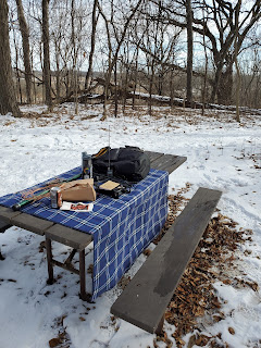
 |
Operating position just getting started. The TP-III is just getting used for PTT, sorry.
|
 |
Continued developing clouds indicating the approaching rain.
|
 |
Vacating the operating position as the sprinkles started to develop further. Teardown of the station was hasty and, fortunately, a well-practiced sequence.
|
In the end, the activation was a couple P2P on 10m, VA5MUD on 15m, taking that 15m frequency and getting a few more, then rounding out with a couple on 17m before the rain. It was a jog up the hill to the parking area to get everything back in the car before the rain really set in.


Comments
Post a Comment